
Course Maps & Descriptions
scroll to: course flyover / detailed descriptions
Course Maps
Click on a course map below to see the full size map in a pop-up window ... or follow the links below each map for different viewers.
21
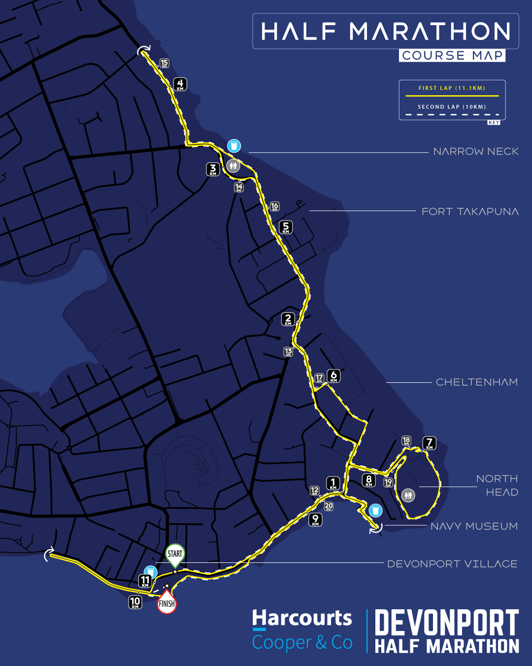
The 21.1km half marathon course comprises two full laps of the 10km course with a 1.1km out-and-back section between laps. The course is scenic and challenging. Held on mostly closed roads with some sections of pavement and grass track. The Half Marathon course begins on fully closed King Edward Parade and follows the exact path later used by the 10k race - out to the turnaround north of Narrow Neck Beach then back via Cheltenham, North Head and the Navy Museum. After completing your first lap, you'll continue past the race site (extra cheers thrown in for free!) and out on the shell path along the seawall to the navy base. Drink in the city skyline and then turn at the boat sheds and return to the race site (more cheers!) before looping back onto the course for your second lap. This extra 1.1km means that as you complete your second lap, you'll turn directly into Windsor Reserve and make your glorious finish.
10
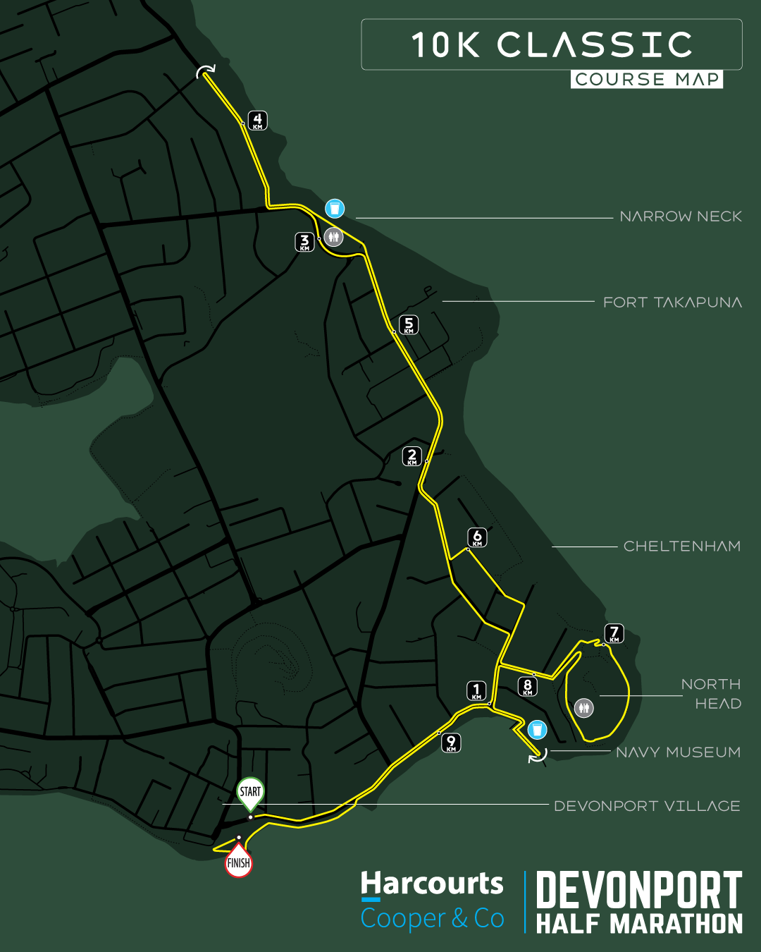
The 10k Classic course is a spectacular tour of the eastern side of the Devonport peninsula which takes in landmark such as Narrow Neck beach, the Torpedo Bay Navy Museum, the Devonport foreshore and the spectacular views from North Head. The course is a mix of closed road running, footpaths, some trail paths through North Head and the shell path on the Devonport seawall. Terrain is mostly flat with a bump on Vauxhall Rd and a gentle rise to the turnaround point plus the more challenging climb up North Head (but, oh, those views!).
5
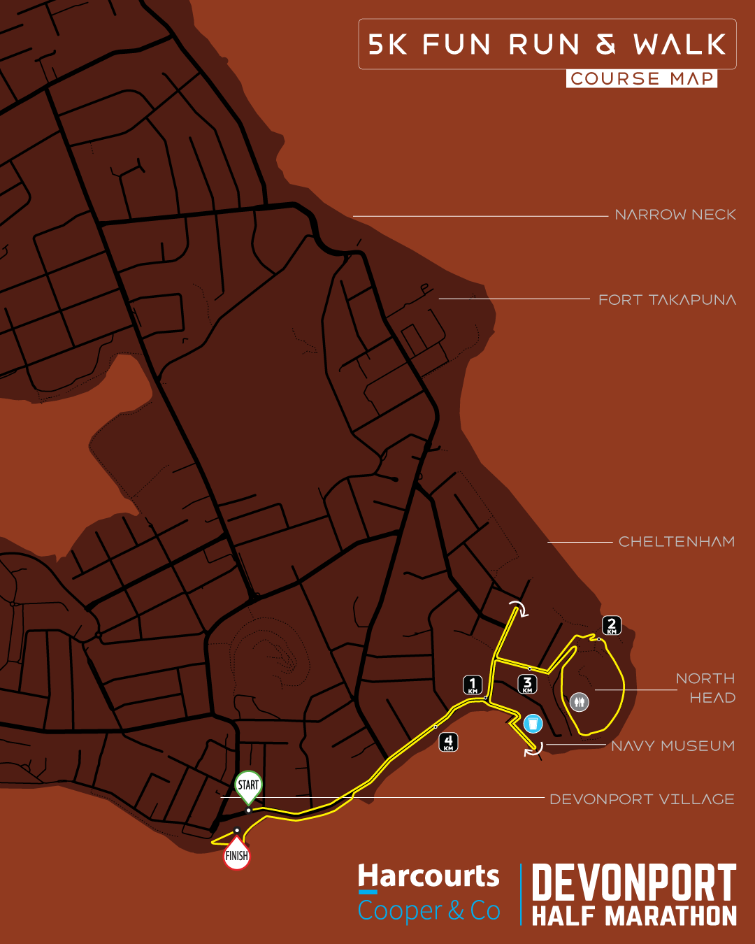
The 5k starts under the main arch in the heart of Devonport Village with the thrill of charging off right down the centre of closed-to-traffic King Edward Parade. After a brief excursion through the leafy, villa-lined streets of Cheltenham, it's time to take on the climb - and enjoy the views! - up and over North Head. You can light the afterburners on the way down from North Head before the turn into the Navy Museum at Torpedo Bay. Collect some welcome sustenance at the aid station and you now have a 1.5km flat dash into the finish line. Thriller!
2
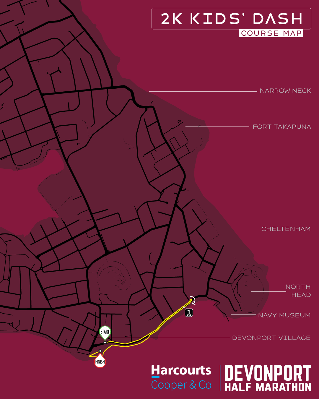
The kid's course takes places entirely within the road closure area on King Edward Parade. Starting under the same massive start arch as the adults, our future Olympians will charge down King Edward Parade towards the navy museum. Just before halfway, they will do a 360 to head back the way they came. At the 3/4 mark they will bear off the road and onto the shell seawall path that takes them all the way around the east and south of Windsor Reserve before the glorious gallop down the finish line!
JOIN JASE & ROB FROM RUNNING EVENTS FOR A LAP OF THE DHM COURSE
Course Tour Videos
STEP BY STEP / TURN BY TURN
Detailed Course Descriptions
Half Marathon Turn-by-Turn
Km 0.0 | Start | King Edward Parade
Starting under the main arch on King Edward Parade outside the Devonport Library. King Edward Parade is closed to traffic along it's full length and runners will proceed east towards Cheltenham running in the road. You will pass feeder roads on your left as you proceed along King Edward Parade with wide views of the harbour and seawall on your right. Like the looks of this place? The venerable 1900s villas facing the Waitemata along this road have valuations starting north of $4 million!
Important! A public toilet is on the seaward side of the road at approx 0.5km.
KM 1.0 | Turn Left > Cheltenham Rd
The 1km marker is right at the junction of King Edward Parade and Cheltenham Road. You will turn left here, staying in the centre of the road.
KM 1.3 | Turn Left > Tainui Road
You will pass historic villas on both sides of this tree-line road. On your right, 2/3 of the way down Tainui Road, you'll pass Rata St, which you will turn into on your way back and at some point you will see runners on the other side of the road. As you approach the junction with Vauxhall Rd, remain on the left side of Tainui Rd until you meet Vauxhall. The road begins to rise gently towards the end of Tainui.
KM 1.9 | Turn Right > Vauxhall Road
Vauxhall Rd is one of the main throughfares on the peninsula and we are fortunate to have a lane closure for the event, meaning one half of the road is for the exclusive use of runners. For the next 1.4km, runners heading north (outward) will run in the road on the right hand (seaward) lane, whilst vehicles will be allowed to use the left (landward) lane to drive in a northerly direction only. Runners returning from the turnaround (see below) will use the footpath on Vauxhall. Look out for the informational boards at this junction showing exactly which section of the road you should be running in.
The first 500 metres of Vauxhall Rd features a modest uphill gradient until the navy facilities around the 2.5km mark. From here, you will crest the hill and start heading downhill with spectacular views of Narrow Neck Beach ahead. On your right, you will pass Fort Takapuna Historic Reserve (which served as race venue from 2013-2015).
KM 2.8 | Ahead/BearRight > Old Lake Road
Arriving at the bottom of the hill into Narrow Neck Beach, the boat ramp accessway is on your right but the main road - which you will follow - bends around to the left as it becomes Old Lake Rd. Keep running in the seaward lane as you bypass the Narrow Neck Yacht Club, cafe and reserve and pass the main beach car park on your left. Just beyond the car park is the 3km mark where the road curves back towards the beach. The road meets the coast at the northen end of Narrow Neck Beach where it begins to climb uphill and then turn westward and away from the sea. Throughout this section you will continue to run on the seaward (right) lane with vehicular traffic using the left lane.
KM 3.2 | Turn Right > Hamana Street
Turn into Hamana Street from Old Lake Road. Hamana Street (which merges into Seacliffe Ave) is fully closed to traffic all the way to the turnaround point. As you turn into Hamana, note the informational signage instructing you to move into the left (landward) lane. From here all the way to the turnaround marker and back, runners will run on the left side of the road, making full use of both lanes of the roadway. That means you run on the landward side of the road as you head north towards the turnaround point and run on the seaward side of the road as you head south after the turnaround. Hamana and then into Seacliffe, the road continues to climb at a modest grade all the way to the turn point.
KM 3.7 | Turnaround Point / Seacliffe Ave
The turnaround point is located just south of Montgomery Avenue. Do a 180 degree turn here and proceed back the way you came, now running on the seaward side of the road. Shortly after the turn, you'll pass the 4km marker.
KM 4.3 | Turn Left > Old Lake Rd
As you exit Hamana St back onto Old Lake Rd, you'll be directed onto the seaward footpath as you head downhill towards the beach. You'll find yourself seperated from runners still heading towards the turnaround by a raised crash barrier.
KM 4.5 | Ahead > Narrow Neck Foreshore
At the bottom of the hill, where the road diverts inland, continue ahead on the footpath. You'll pass a bus shelter on your left before the footpath opens out onto the access road that runs along the edge of Narrow Neck Beach. As the road widens, you'll find the Narrow Neck Beach public toilets on your right and our first aid station right outside.
The beach side road continues past the toilets and past the Narrow Neck Yacht Club to the public boat ramp. Throughout this section, it's important to remain alert for obstacles and vehicle movements, particularly if the weather is good and the boat ramp becomes busy. Our marshals will help you to navigate your way through this section.
KM 4.7 | Ahead > Vauxhall Rd
Beyond the boat ramp, you will remain on the footpath and behind a crash barrier separating the footpath from the boat ramp accessway. From here, the road climbs back up out of Narrow Neck Beach and towards Fort Takapuna. This is a reasonably taxing climb for the next 300 metres - still on the footpath - until you reach the navy barracks on your left. Take care at this point for any traffic emerging from Fort Takapuna or the barracks. You will continue on the wide seaward footpath of Vauxhall Rd all the way downhill to Tainui Road.
KM 5.6 | Turn Left > Tainui Rd
Almost at the bottom of the hill on Vauxhall Rd, take extra care going past the entrance to the Gull Service Station (which vehicles are not permitted to use during the lane closure - but that may not stop them). As you turn into Tainui, you will step off the footpath and onto the road. You will be running on the road all the way to North Head. There is a gentle downslope on Tainui as you pass the wide mouth of Arawa Ave. Continue on until you reach Rata St.
KM 5.9 | Turn Left > Matai Rd
Staying on the road, turn left into Matai Rd for a short section. The terrain is dead flat now until you turn into North Head.
KM 6.0 | Turn Right > Oxford Terrace
Remaining on the road, turn right into Oxford Terrace where you will see the 6km mark right as you enter. Oxford Terrace is quintessential Devonport with beautiful villas on both sides behind picket fences and hedges. 2/3 of the way down, the road kinks gently to the left at the junction with Eton Avenue. Continue on to the T-junction with Cheltenham Road.
KM 6.4 | Turn Right > Cheltenham Road
As you turn into Cheltenham Road, you'll have a glimpse of Cheltenham Beach and the entrance to the famous McHughs of Cheltenham restaurant on your left. Turn away from the beach and continue down the road towards the turn into North Head. Stay on the right side of the road here as you may encounter runners on the other side of the road past Tainui.
KM 6.5 | Turn Left > Takarunga Road
Turning into Takarunga Road, the gradient immediately starts heading up as you climb towards the North Head entrance gates. Keep on the left side of the road - runners exiting North Head will be on the other side of the road from you.
KM 6.7 > KM 7.9 | North Head
Entering North Head, you will bear left off the road and onto a grass path. Follow the path to the first gun emplacement and then take the zig-zag ramp up to the eastern car park. Past the car park, climb up over the bunker entrance. Pause for a moment - the toughest part of the climb is behind you and a spectacular view of Rangitoto Island the Rangitoto Channel is ahead. Behind you is a signature view of Cheltenham Beach.
Follow the ridge track around North Head and you will see views open up to Mission Bay and the eastern suburbs. A short hill takes you up to and around the front of the amazing "Disappearing Gun". Passing the gun you will turn back towards the park entrance with a public toilet on your right. Just past this point you rejoin the main North Head road and follow it down past a hairpin turn to the exit at the main gate.
KM 7.9 | Ahead > Takarunga Road
Exiting North Head, it's a sharp downhill on Takarunga Rd.
KM 8.1 | Turn Left > Cheltenham Road
Back onto Cheltenham Road, you are now heading directly towards the harbour.
KM 8.2 | Turn Left > King Edward Parade
As Cheltenham Road meets King Edward Parade at a T-junction on the sea front, turn left on King Edward for the short section leading into the Navy Museum.
KM 8.3 > KM 8.6| Navy Museum at Torpedo Bay
An out-and-back section takes in the beautiful manicured grounds of the Navy Museum at Torpedo Bay. Just after passing the museum entrance, you'll encounter an aid station. Continue past the aid station to the turnaround and retrace your steps back out onto King Edward Parade.
KM 8.6 | Ahead > King Edward Parade
The final 1.4km of the lap are absolutely flat and follow King Edward Parade and the sea wall back to the village.
KM 9.3 | Turn Left > King Edward Parade Sea Wall
With 700m of the lap remaining, you'll be directed off the road and onto the shell path next to the sea wall. This will take you all the way to Windsor Reserve. Once at the reserve, bear left again to join the Devonport Beach promenade around the east and south sides of Windsor Reserve to the Lap Split / Decision Point.
KM 9.9 | LAP SPLIT / DECISION POINT
Running along the sea wall on the southern side of Windor Reserve, keep to the left where directed and continue on past the turn into the finish line. You have now completed Lap One. On your next lap, you'll keep to the right on this section before turning into the finish line.
KM 10 | Ahead / Queens Parade Sea Wall
Continuing on past the event venue , take extra care running past the main doors to the Devonport Ferry Terminal. Just beyond the Ferry Terminal, join the shell path along the sea wall and continue along here all the way to the boat sheds at the navy base. You'll enjoy spectacular views of the city all the way.
KM 10.4 | Turnaround / Queens Parade Boat Sheds
As you reach the boat sheds at the city end of Queens Parade, turn around the marker and retrace your steps back to Windsor Reserve.
KM 10.9 | Turn Left / Victoria Road
Adjacent to the entrace to the finish chute, bear left onto Victoria Road but remain on the footpath. Follow the footpath north. You will pass an aid station dedicated for half marathoners about to begin their second lap.
KM 11.0 | Turn Right / King Edward Parade
Turn right at the intersection with King Edward Parade and you will be diverted from the footpath back onto the road - take extra care in this area as there are a lot of spectators and other runners milling around who are not always fully attentive to athletes heading out on their second lap. Once onto the road next to the library, you have the main Start Arch ahead. As you pass under the arch, you are now beginning Lap Two. The start area portaloos are available to you on the left side of the road before the arch.
KM 11.1 > 21.0 | LAP TWO
You now follow the exact instructions from KM 0 to KM 9.9 above, until ...
KM 21.0 | Turn Right / Finish Line
As you arrive once again at the sea wall on the southern side of Windor Reserve, keep to the RIGHT where directed and TURN RIGHT into Windsor Reserve.
The finish line is ahead of you.
Congratulations ... you made it!
10k Turn-by-Turn
Km 0.0 | Start | King Edward Parade
Starting under the main arch on King Edward Parade outside the Devonport Library. King Edward Parade is closed to traffic along it's full length and runners will proceed east towards Cheltenham running in the road. You will pass feeder roads on your left as you proceed along King Edward Parade with wide views of the harbour and seawall on your right. Like the looks of this place? The venerable 1900s villas facing the Waitemata along this road have valuations starting north of $4 million!
Important! A public toilet is on the seaward side of the road at approx 0.5km.
KM 1.0 | Turn Left > Cheltenham Rd
The 1km marker is right at the junction of King Edward Parade and Cheltenham Road. You will turn left here, staying in the centre of the road.
KM 1.3 | Turn Left > Tainui Road
You will pass historic villas on both sides of this tree-line road. On your right, 2/3 of the way down Tainui Road, you'll pass Rata St, which you will turn into on your way back and at some point you will see runners on the other side of the road. As you approach the junction with Vauxhall Rd, remain on the left side of Tainui Rd until you meet Vauxhall. The road begins to rise gently towards the end of Tainui.
KM 1.9 | Turn Right > Vauxhall Road
Vauxhall Rd is one of the main throughfares on the peninsula and we are fortunate to have a lane closure for the event meaning one half of the road is for the exclusive use of runners. For the next 1.4km, runners heading north (outward) will run in the road on the right hand (seaward) lane, whilst vehicles will be allowed to use the left (landward) lane to drive in a northerly direction only. Runners returning from the turnaround (see below) will use the footpath on Vauxhall. Look out for the informational boards at this junction showing exactly which section of the road you should be running in.
The first 500 metres of Vauxhall Rd features a modest uphill gradient until the navy facilities around the 2.5km mark. From here, you will crest the hill and start heading downhill with spectacular views of Narrow Neck Beach ahead. On your right, you will pass Fort Takapuna Historic Reserve (which served as race venue from 2013-2015).
KM 2.8 | Ahead/BearRight > Old Lake Road
Arriving at the bottom of the hill into Narrow Neck Beach, the boat ramp accessway is on your right but the main road - which you will follow - bends around to the left as it becomes Old Lake Rd. Keep running in the seaward lane as you bypass the Narrow Neck Yacht Club, cafe and reserve and pass the main beach car park on your left. Just beyond the car park is the 3km mark where the road curves back towards the beach. The road meets the coast at the northen end of Narrow Neck Beach where it begins to climb uphill and then turn westward and away from the sea. Throughout this section you will continue to run on the seaward (right) lane with vehicular traffic using the left lane.
KM 3.2 | Turn Right > Hamana Street
Turn into Hamana Street from Old Lake Road. Hamana Street (which merges into Seacliffe Ave) is fully closed to traffic all the way to the turnaround point. As you turn into Hamana, note the informational signage instructing you to move into the left (landward) lane. From here all the way to the turnaround marker and back, runners will run on the left side of the road, making full use of both lanes of the roadway. That means you run on the landward side of the road as you head north towards the turnaround point and run on the seaward side of the road as you head south after the turnaround. Hamana and then into Seacliffe, the road continues to climb at a modest grade all the way to the turn point.
KM 3.7 | Turnaround Point / Seacliffe Ave
The turnaround point is located just south of Montgomery Avenue. Do a full 360 degree turn here and proceed back the way you came, now running on the seaward side of the road. Shortly after the turn, you'll pass the 4km marker.
KM 4.3 | Turn Left > Old Lake Rd
As you exit Hamana St back onto Old Lake Rd, you'll be directed onto the seaward footpath as you head downhill towards the beach. You'll find yourself separated from runners still heading towards the turnaround by a raised crash barrier.
KM 4.5 | Ahead > Narrow Neck Foreshore
At the bottom of the hill, where the road diverts inland, continue ahead on the footpath. You'll pass a bus shelter on your left before the footpath opens out onto the access road that runs along the edge of Narrow Neck Beach. As the road widens, you'll find the Narrow Neck Beach public toilets on your right and our first aid station right outside.
The beach side road continues past the toilets and past the Narrow Neck Yacht Club to the public boat ramp. Throughout this section, it's important to remain alert for obstacles and vehicle movements, particularly if the weather is good and the boat ramp becomes busy. Our marshals will help you to navigate your way through this section.
KM 4.7 | Ahead > Vauxhall Rd
Beyond the boat ramp, you will remain on the footpath and behind a crash barrier separating the footpath from the boat ramp accessway. From here, the road climbs back up out of Narrow Neck Beach and towards Fort Takapuna. This is a reasonably taxing climb for the next 300 metres - still on the footpath - until you reach the navy barracks on your left. Take care at this point for any traffic emerging from Fort Takapuna or the barracks. You will continue on the wide seaward footpath of Vauxhall Rd all the way downhill to Tainui Road.
KM 5.6 | Turn Left > Tainui Rd
Almost at the bottom of the hill on Vauxhall Rd, take extra care going past the entrance to the Gull Service Station (which vehicles are not permitted to use during the lane closure - but that may not stop them). As you turn into Tainui, you will step off the footpath and onto the road. You will be running on the road all the way to North Head. There is a gentle downslope on Tainui as you pass the wide mouth of Arawa Ave. Continue on until you reach Rata St.
KM 5.9 | Turn Left > Matai Rd
Staying on the road, turn left into Matai Rd for a short section. The terrain is dead flat now until you turn into North Head.
KM 6.0 | Turn Right > Oxford Terrace
Remaining on the road, turn right into Oxford Terrace where you will see the 6km mark right as you enter. Oxford Terrace is quintessential Devonport with beautiful villas on both sides behind picket fences and hedges. 2/3 of the way down, the road kinks gently to the left at the junction with Eton Avenue. Continue on to the T-junction with Cheltenham Road.
KM 6.4 | Turn Right > Cheltenham Road
As you turn into Cheltenham Road, you'll have a glimpse of Cheltenham Beach and the entrance to the famous McHughs of Cheltenham restaurant on your left. Turn away from the beach and continue down the road towards the turn into North Head. Stay on the right side of the road here as you may encounter runners on the other side of the road past Tainui.
KM 6.5 | Turn Left > Takarunga Road
Turning into Takarunga Road, the gradient immediately starts heading up as you climb towards the North Head entrance gates. Keep on the left side of the road - runners exiting North Head will be on the other side of the road from you.
KM 6.7 > KM 7.9 | North Head
Entering North Head, you will bear left off the road and onto a grass path. Follow the path to the first gun emplacement and then take the zig-zag ramp up to the eastern car park. Past the car park, climb up over the bunker entrance. Pause for a moment - the toughest part of the climb is behind you and a spectacular view of Rangitoto Island the Rangitoto Channel is ahead. Behind you is a signature view of Cheltenham Beach.
Follow the ridge track around North Head and you will see views open up to Mission Bay and the eastern suburbs. A short hill takes you up to and around the front of the amazing "Disappearing Gun". Passing the gun you will turn back towards the park entrance with a public toilet on your right. Just past this point you rejoin the main North Head road and follow it down past a hairpin turn to the exit at the main gate.
KM 7.9 | Ahead > Takarunga Road
Exiting North Head, it's a sharp downhill on Takarunga Rd.
KM 8.1 | Turn Left > Cheltenham Road
Back onto Cheltenham Road, you are now heading directly towards the harbour.
KM 8.2 | Turn Left > King Edward Parade
As Cheltenham Road meets King Edward Parade at a T-junction on the sea front, turn left on King Edward for the short section leading into the Navy Museum.
KM 8.3 > KM 8.6| Navy Museum at Torpedo Bay
An out-and-back section takes in the beautiful manicured grounds of the Navy Museum at Torpedo Bay. Just after passing the museum entrance, you'll encounter an aid station. Continue past the aid station to the turnaround and retrace your steps back out onto King Edward Parade.
KM 8.6 | Ahead > King Edward Parade
The final 1.4km of the lap are absolutely flat and follow King Edward Parade and the sea wall back to the village.
KM 9.3 | Turn Left > King Edward Parade Sea Wall
With 700m of the lap remaining, you'll be directed off the road and onto the shell path next to the sea wall. The will take you all the way to Windsor Reserve. Once at the reserve, bear left again to join the Devonport Beach promenade around the east and south sides of Windsor Reserve to the Lap Split / Decision Point.
KM 9.9 | Turn Right / Finish Line
As you proceed along the sea wall on the southern side of Windor Reserve, keep to the RIGHT where directed and TURN RIGHT into Windsor Reserve.
The finish line is ahead of you.
Congratulations ... you made it!
5k Turn-by-Turn
Km 0.0 | Start | King Edward Parade
Starting under the main arch on King Edward Parade outside the Devonport Library. King Edward Parade is closed to traffic along it's full length and runners will proceed east towards Cheltenham running in the road. You will pass feeder roads on your left as you proceed along King Edward Parade with wide views of the harbour and seawall on your right. Like the looks of this place? The venerable 1900s villas facing the Waitemata along this road have valuations starting north of $4 million!
Important! A public toilet is on the seaward side of the road at approx 0.5km.
KM 1.0 | Turn Left > Cheltenham Rd
The 1km marker is right at the junction of King Edward Parade and Cheltenham Road. You will turn left here, staying in the centre of the road.
KM 1.3 | Turnaround
Heading directly towards Cheltenham Beach - with famous McHughs of Cheltenham restaurant straight ahead - you'll reach the turnaround point. Do a 360 here and return along Cheltenham Rd for a short distance before ...
KM 1.5 | Turn Left > Takarunga Road
Turning into Takarunga Road, the gradient immediately starts heading up as you climb towards the North Head entrance gates. Keep on the left side of the road - runners exiting North Head will be on the other side of the road from you.
KM 1.7 > KM 2.9 | North Head
Entering North Head, you will bear left off the road and onto a grass path. Follow the path to the first gun emplacement and then take the zig-zag ramp up to the eastern car park. Past the car park, climb up over the bunker entrance. Pause for a moment - the toughest part of the climb is behind you and a spectacular view of Rangitoto Island the Rangitoto Channel is ahead. Behind you is a signature view of Cheltenham Beach.
Follow the ridge track around North Head and you will see views open up to Mission Bay and the eastern suburbs. A short hill takes you up to and around the front of the amazing "Disappearing Gun". Passing the gun you will turn back towards the park entrance with a public toilet on your right. Just past this point you rejoin the main North Head road and follow it down past a hairpin turn to the exit at the main gate.
KM 2.9 | Ahead > Takarunga Road
Exiting North Head, it's a sharp downhill on Takarunga Rd.
KM 3.1 | Turn Left > Cheltenham Road
Back onto Cheltenham Road, you are now heading directly towards the harbour.
KM 3.2 | Turn Left > King Edward Parade
As Cheltenham Road meets King Edward Parade at a T-junction on the sea front, turn left on King Edward for the short section leading into the Navy Museum.
KM 3.3 > KM 3.6| Navy Museum at Torpedo Bay
An out-and-back section takes in the beautiful manicured grounds of the Navy Museum at Torpedo Bay. Just after passing the museum entrance, you'll encounter an aid station. Continue past the aid station to the turnaround and retrace your steps back out onto King Edward Parade.
KM 3.6 | Ahead > King Edward Parade
The final 1.4km of the lap are absolutely flat and follow King Edward Parade and the sea wall back to the village.
KM 4.3 | Turn Left > King Edward Parade Sea Wall
With 700m of the lap remaining, you'll be directed off the road and onto the shell path next to the sea wall. The will take you all the way to Windsor Reserve. Once at the reserve, bear left again to join the Devonport Beach promenade around the east and south sides of Windsor Reserve to the Lap Split / Decision Point.
KM 4.9 | Turn Right / Finish Line
As you proceed along the sea wall on the southern side of Windor Reserve, keep to the RIGHT where directed and TURN RIGHT into Windsor Reserve.
The finish line is ahead of you.
Congratulations ... you made it!
Kids' Dash Turn-by-Turn
Km 0.0 | Start | King Edward Parade
Starting under the main arch on King Edward Parade outside the Devonport Library. King Edward Parade is closed to traffic along it's full length and runners will proceed east towards Cheltenham running in the road.
KM 0.9 | Turnaround
Almost up to the end of King Edward Parade, Kids make a 360 in the road and retrace their route, keeping on the LEFT of the road ...
KM 1.3 | Turn Left > King Edward Parade Sea Wall
With 700m of the lap remaining, you'll be directed off the road and onto the shell path next to the sea wall. The will take you all the way to Windsor Reserve. Once at the reserve, bear left again to join the Devonport Beach promenade around the east and south sides of Windsor Reserve to the Lap Split / Decision Point.
KM 1.9 | Turn Right / Finish Line
As you proceed along the sea wall on the southern side of Windor Reserve, keep to the RIGHT where directed and TURN RIGHT into Windsor Reserve.
The finish line is ahead of you.